
Centimeter Level Accuracy GNSS RTK System Satellite Signals Tracked Simultaneously 220 Channels GPS……….. Simultaneous L1C/A, L2C...
Add to Cart
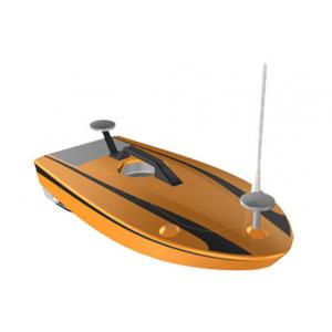
... Boat. Model No. HV-USV009 Hull Material Carbon Fiber and Fiber Glass Hull Length 105cm Hull Width 50cm Weight 12kg Payload 10kg ...
Add to Cart

Kolida 472R10L Wireless Reflectorless Staton Instruments Total Station Specification Models and technical parameters 472LL 472R4L 4...
Add to Cart
UAV LiDAR Scanning System Geosun GS-100C+ Livox Avia Topographic Surveying And Mapping Solution 5-Power supply Power supply for galvo head and control...
Add to Cart
China Superior Instrument RTK Positioning The V60 is a more compact-design and higher-performance GNSS RTK system, besides its rug...
Add to Cart
Multi platform highly integrated airborne LiDAR survey ARS-1000 with the range accuracy of 15mm@150m ARS-1000 airborne LiDAR survey is developed and b...
Add to Cart
GPS Survey High Accuracy Land Distance Area Measuring Handheld GPS Surveying Units Normal area measurement of Handheld GPS Surveying Units 1. At the s...
Add to Cart
... Total Station) incorporates all the features you need at a -efficient price. Sokkia iM101 /iM105 Manual Total Station will handle your most de...
Add to Cart
... Equipment FOIF high-brightness color screen intelligent total station, built-in large-capacity memory and various application measurement...
Add to Cart
Lashing Survey LS Make Sure Products Equipment Lashed Correct Way 1. Cargo lashing survey on board vessels. 2. Cargo lashing survey on all type of con...
Add to Cart
... is designed to be foldable, reducing floor space and having low maintenance . Industry application fields: fire extinguishing and fire protec...
Add to Cart
... Instruments A Proton Precession Magnetometer is an instrument that measures the scalar intensity of the local magnetic field and relies upon...
Add to Cart
... FLA.00.250 Description: 00S Coaxial cable connectors FFA.00.250 Applications: ing and mapping, sound devices Size: 00S, 0S,1S Factory ...
Add to Cart
Terrain Mapping Aerial Surveying Geosun UAV LiDAR GS-130X High Precision Cost-Effective Cost Highly Integration Geosun gAirHawk Series GS-130X UAV LiD...
Add to Cart
... Instrument Model: GDF101 Highlights: A effective tribrach suitable for use in normal environments. Suitable for all light-weight instru...
Add to Cart
... Station Sokkia iM 55 Angle Accuracy 5" Magnification30x red laser The Sokkia iM 55 Total Station is the perfect entry-level site layout and...
Add to Cart
5-60m PPM-CSB Hydrographic Survey Ultrasonic Water Level Transmitter Description PPM-CSB Ultrasonic Liquid Level Transmitter is a kind of non-contact,...
Add to Cart
Product Description: Our Portable Water Well Drilling Rig is cost-effective and perfect for geological survey drill or person drilling rig. This rig i...
Add to Cart
... to inspect the most of te pipes, reduce the . It is compoposed of a crawler, pan&tilt camera, automatic cable drum and control units. The craw...
Add to Cart
Used for Natural seismic 2Hz±10% Low 3 Component Geophone of Rock Layer Features of 3 Component Geophone Good parameter consistency, firm ...
Add to Cart