... photogrammetry, which is more effective for the of small-scale . Facing the operation demand of large-scale ...
Add to Cart

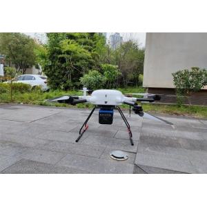
gAirHawk GS-260S UAV LIDAR SCANNING SYSTEM Drone LiDAR Scanning System mounted on DJI M300 Application for gAirHawk GS-260S is a k...
Add to Cart

Windows CE Modern Design Total Station The ZTS-360/R is configured with advanced dual-axis compensatorfor auto error elimination...
Add to Cart
24LB 28LB Coated Bond CAD Plotter Paper Roll For Printing Colored Topographic Map ► Coated CAD Plotter Paper Description Weight 20lb, 24lb, 28lb, 32lb...
Add to Cart
The KLSA-PN laser ranging sensor for Introduction Laser distance sensor is a precision instrument that uses laser technology to ac...
Add to Cart
Item Name: Outdoor building 3D mapping projection ProductModel: NL-5000LmW, NL-6000LmW,NL-7500LmW, NL-8500LmW,NL-10000LmW, NL-15000LmW,NL-20000LmW Pow...
Add to Cart
Stonex GNSS RTK receiver controller software Surpad registration code Surveying instrument software...
Add to Cart
...
Add to Cart
Product Introduction Hi-target GPT3502Ln Total Station Class1 Safe Pulse Laser EDM Laser Pointer for Reflectorless Measurement and Layout Point Guide ...
Add to Cart
...-traffic environments. By combining real sand with dynamic projection and real-time depth sensing, the table converts physical terrain into...
Add to Cart
...-traffic environments. By combining real sand with dynamic projection and real-time depth sensing, the table converts physical terrain into...
Add to Cart
UAV LiDAR Scanning System Geosun GS-100C+ Livox Avia Topographic Surveying And Mapping Solution 5-Power supply Power supply for galvo head and control...
Add to Cart
SW-6000 China Ophthalmic equipment Corneal Topography Corneal Topography SW-6000: By PLACIDO cone, 31 rings, a total of 7936 points. Through calculati...
Add to Cart
... web based GPS tracking systemvehicle car tracking for GPS Tracking Model TB05 ( Enterprise edition GPS monitoring and management syst...
Add to Cart
...; 2.can use the video player, play any video; 3.can use the music player, play any songs; 4.You can log in to Google PLAY online and download any s...
Add to Cart
..., Platform, System For Fleet Easy Management Jointech Cloud GPS tracking for fleet management. Jointech clould tracking a...
Add to Cart
.pd-container { font-family: Arial, sans-serif; color: #333; line-height: 1.6; max-width: 100%; margin: 0 auto; padding: 15px; box-sizing: border-box;...
Add to Cart
Touchscreen: It includes six interfaces: initial interface , operation map , remote monitoring, load loading, alarm query and parameter setting . Ø Ho...
Add to Cart
[Second Hand US Ship] TOPDON Phoenix Plus Integrated Diagnostic Tool Bi-Directional Control Topology Mapping 41 Maintenance Services ECU Coding VAG [S...
Add to Cart
... controller. Through the use of Driver which true "contents" pose for reading the files contained in the control units, you can easily find the dat...
Add to Cart