Product Details
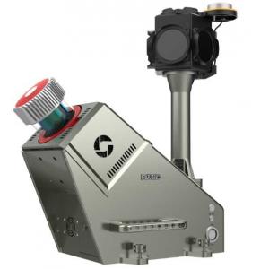
420m@80% range 5mm@30m accuracy HiScan-R Lightweight Mobile LiDAR
System with 0.001° angular resolution
HiScan-R lightweight mobile LiDAR system is mobile surveying and
mapping equipment based on Riegl LiDAR and launched by Wuhan
Hi-Cloud Technology Co., Ltd. It integrates modules like 2D laser
scanning equipment (LS), satellite positioning module (GNSS),
inertial navigation unit (IMU), wheel encoders, panoramic cameras,
assembly control module and high-performance board computer, etc..
It can collect point cloud data and panoramic images in real-time.
It is convenient to install in various carriers such as cars, beach
buggies, ships or other mobile carriers. The production and
processing of vector map data, street view data and geographic data
can be easily completed during the movement of the carriers. It is
widely used in topographic survey, urban municipal component
survey, urban garden survey, traffic survey and design, traffic
information survey, street view map service, digital city, waterway
and island survey and other fields.
Specification
HiScan-R Lightweight Mobile LiDAR System
| Items | Parameters |
| Number of Scanners | 1 |
| Range Measurement | 420m@80% reflectivity |
| Laser Frequency | Max. 1,000,000points/s |
| Range Accuracy | 5mm@30m |
| Angular Resolution | 0.001° |
| Panoramic Camera | 30M pixels |
| Accuracy | 5cm@100m |
| Scan Speed | 10-250 scans/s |
| Positioning Accuracy (no lock loss, post-processing) | horizontal 0.01m |
| vertical 0.02m |
| Orientation Accuracy (no lock loss, post-processing) | heading 0.004° |
| pitch/roll 0.003° |
Features
- Integration: highly integrated, light vehicle platform suitable for
different models.
- Retractable: retractable roof rack, effectively solving the problem
of rear shielding of different models.
- High precision: high point cloud density, high point recognition
rate, high measurement accuracy.
- Calibration-free: calibration is completed before delivery.
- High intelligence: seamless integration of point cloud and
panorama.
- Adjustable: support left and right angle adjustment of 30°/60°,
obtain more comprehensive data.
- Lightweight: small size and multiple carriers, greatly reducing the
blind area of operation.
- Easy to store: pluggable data storage design.
Application Fields
It can be widely used in street view maps, cadastral surveys, urban
municipal component surveys, traffic survey informatization, urban
landscaping surveys, digital/smart 3D city, digital waterways,
island and reef survey and other fields.
i. Internet street view map
ii. Basic topographic mapping
iii. Urban municipal component survey
iv. Urban landscaping survey
v. Highway survey and intelligent transportation
vi. Digital 3D city
Company Profile
Hi-Cloud -- the leader of 3D laser scanning technology
Wuhan Hi-Cloud Technology Co.,Ltd. founded in 2012, and is a
holding company of Guangzhou Hi-Target Satellite Navigation
Technology Co.,Ltd (stock code: 300177) with more than 200 team
members and a product service network covering the whole country.
Hi-Cloud has been committed to the development, application service
and industrialization of high-precision 3D laser series products
for long term. It has taken the lead in overcoming the key core
technology of full waveform LiDAR, breaking the long-term monopoly
of foreign technology. It has formed a full series of product line
layout of 3D laser "sea, land and air", and is far ahead in the
application field of high-precision of domestic equipment. It is
one of the few 3D laser solution providers in China that fully
master the core technology of LiDAR and realize industrialization.
Products and technologies are widely used in geographic information
surveying and mapping , digital city, industrial digitization and
other fields to provide technical support for the construction and
application of digital 3D world.
Hi-Cloud has applied for and owned 105 patents, 48 software
copyrights, won a number of provincial and ministerial scientific
and technological progress awards, won the title of "Gazelle
Enterprise" in Wuhan East Lake Hi-Tech District for six consecutive
years, and has been successively rated as a “High-Tech Enterprise”,
Hubei enterprise technology center, an "Invisible Champion" in
market segments, and "Little Giant" enterprise in Hubei Province.
In the future, Hi-Cloud will always adhere to the localization of
high-end equipment as its own responsibility, and continue to
promote the industrialization of domestic high-precision LiDAR,
committed to become a global leader of 3Dlaser scanning technology.