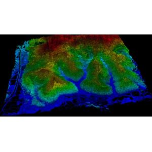
GS-260X LiDAR Scanning System HESAI XTM2X Sensor High Accuracy Terrain Mapping Geosun gAirHawk Series GS-260X LiDAR Scanning System gAir...
Add to Cart
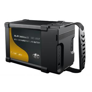
High Power 44.4V 16000mAh Lithium Ion Battery For Plant Protection Mapping Drones Rated Capacity 16000 mAh @ 0.2C Min. Capacity 15500 m...
Add to Cart

Knowledge Transfer: Making Experts Out of Beginners Demystifying Geophysical Expertise Complex exploration technology becomes intuitively accessible t...
Add to Cart
... mapping drone Long range aerial fixed wing mapping drone Material Carbon Fiber Function Public Safety Mapping Surveillance Color Cu...
Add to Cart
... navigation and positioning system and high-performance imaging system, portable and easy to use, comprehensively improving aerial efficienc...
Add to Cart
... Data Link Support Pixhawk High Definition Multimedia Interface Vido Input TTL Serial Ports CD30HPT Drone Video Transmitter & Receiver Specifi.....
Add to Cart
... Data Link is a versatile product that supports LAN, TTL, RS232, and HDMI data links. This means that you can use it with a wide range of device...
Add to Cart
4.4kg high precision 5mm@50m long range 1500m high frequency 2000kHz PM-1500 LiDAR System for road and design Transportation industry is a ...
Add to Cart
... VTOL is a cutting-edge product designed to meet the demands of professional aerial operations. With a maximum transmission distance of 150 Km, ...
Add to Cart
... for , mapping, surveillance and inspection. At the same time, HXN1-B is a type of multi-rotor . With its 90-minute battery life, centi...
Add to Cart
... for Professional Missions The Autel EVO II Enterprise V3 redefines commercial drone performance with game-changing upgrades—from 15km long-rang...
Add to Cart
... for Aerial Product features: Light, high strength, excellent fatigue strength, strong pulling, Low noise Precise dynamic-static balance...
Add to Cart
UAV LiDAR Scanning System Geosun GS-100C+ Livox Avia Topographic Surveying And Mapping Solution 5-Power supply Power supply for galvo head and control...
Add to Cart
...grade , that is widely used in forest firefighting, industrial area firefighting, building firefighting, remote area firefighting, etc., with ap...
Add to Cart
SE39 Medium Size Drone Hybrid Wing Ultra-Long Endurance Aerial Drone 1. Oil/electric power optional. The electric version is easy to mai...
Add to Cart
... scrolling or portability, easy to carry and quick deployment in 2 minutes Simple operation: after the connection is powered on powered tethered re...
Add to Cart
Product Description The Semi-Solid State Drone Battery is engineered for high-performance drone applications requiring reliable power, high energy den...
Add to Cart
...r drone operations to the next level with our Advanced Fiber Optic Cables. Offering both single-mode and multi-mode configurations, these cable...
Add to Cart
..., disaster monitoring, meteorological observation, air traffic control, border control, communication relay, pipeline investigation, power li...
Add to Cart
... flight times, and unreliable battery performance. Whether you are racing, , or flying heavy-lift , your drone needs a power source th...
Add to Cart