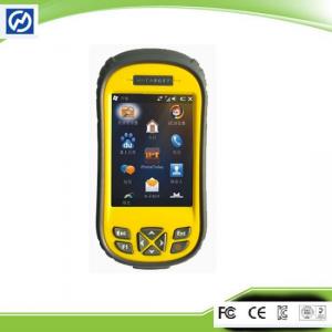
Ordnance Survey Datum GIS Data Collection for Power Line Inspection With Windows Mobile 6.5 you may upload necessary utilities or software on your Qmi...
Add to Cart
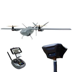
UAV Mapping Drone Nimbus Long Endurance VTOL UAV Drone with PPK for Precision Mapping and Survey Foxtech Nimbus VTOL V2 for Mapping and Survey(DA16 wi...
Add to Cart

Surveying & Mapping Drone CT-15 Rotor 6 Stage Fixed Wing Drone Introduction: CT-15 fixed-wing unmanned aerial vehicle is a composite wing aircraft...
Add to Cart
GS-260X LiDAR Scanning System HESAI XTM2X Sensor High Accuracy Terrain Mapping UAV Surveying Geosun gAirHawk Series GS-260X LiDAR Scanning System gAir...
Add to Cart
Industrial UAV Drone Mapping Construction Space Imaging Mineral Industry Electric Aircraft Description The most compact drone of its class Deploy &...
Add to Cart
HXN1-R 16m/S Cruising Speed Land Surveying 1.4Hours Endurance UAV Camera 3D Mining Urban Modeling Aerial Mapping Drone ⇨Foldable Body The flexible and...
Add to Cart
450m/650m/1200m above water range 360°×100° FoV 15cm@100m accuracy iAqua LiDAR mobile mapping system for reef survey The traditional topographic surve...
Add to Cart
Magnetic Survey Instruments Transient Electromagnetic Equipment Magnetic survey instruments are used in a variety of applications, including mineral e...
Add to Cart
30KM Very Larger Range UAV Video Data Link Mavlink 1080P for Mapping Drone 30km Fixed Wing UAV Data Link Support Pixhawk High Definition Multimedia In...
Add to Cart
LSBM-100 Surveying and Mapping Laser Ranging Module Product Introduction The LSBM-100 Surveying and Mapping Laser Ranging Module is an excellent choic...
Add to Cart
Sub-centimeter Precision RTK Surveying And Mapping Base And Rover Equipment Main Specification: Satellite Signal Tracked Simultaneously 220 Channels G...
Add to Cart
Revolutionize Your Surveying with 3D Imaging Geophysical Survey Equipment Product Description: 300m natural electric field a key to mapping geophysica...
Add to Cart
Product Description: The Surveying Instrument is a highly advanced and precise tool designed for professional surveyors and engineers. With a measure ...
Add to Cart
SMbus communication protocol smart battery 7.4 Volt 3500mAh Surveying and mapping Battery for Trimble Survey Instruments We can make any customized ba...
Add to Cart
GPS Land Measuring Instrument Survey Equipment Portable Outdoor Land Area Meter Main Functions: 2.Measurement Function:Area measurement,distance measu...
Add to Cart
FOIF DSZ2 Optical transit surveying and mapping instrument Auto Level For tunnel construction of engineering survey Overview Error 1mm Magnification 3...
Add to Cart
3d Digital Compass Orientation Sensor Surveying And Mapping Antenna North Search ▶ MAIN FEATURE ★ Heading Accuracy: 0.5° ★ Roll Measure Range:±180° ★ ...
Add to Cart
Compact and Light Weight Inertial Imu Sensor Product Description The 16488HA inertial measurement unit is a complete inertial system with a built-in t...
Add to Cart
Mineral survey Protable Proton Magnetometer Application 1.Mineral survey, such as iron ore, lead-zinc ore, copper ore 2.Mineral prospecting as mineral...
Add to Cart
High Power 44.4V 16000mAh Lithium Ion Battery For Plant Protection UAV, Surveying Mapping Drones Rated Capacity 16000 mAh @ 0.2C Min. Capacity 15500 m...
Add to Cart