Home /Water Treatment /

500kv Power Line Inspection Drone LiDAR Scanning System Geosun GS-260X PPK RTK Processing

500kv Power Line Inspection Drone LiDAR Scanning System Geosun GS-260X PPK RTK Processing

Brand Name:Geosun
Certification:CE, ISO
Model Number:GS-260X Drone LiDAR Scanning System
Minimum Order Quantity:1
Delivery Time:10-15 works days
Payment Terms:T/T, Western Union
Contact Now

Add to Cart

Verified Supplier
Location: Wuhan Hubei China
Address: 4F, Building D, Tianyi plaza No.8 West Maodianshan Road, East Lake Hi-tech Zone Wuhan City, China
Supplier`s last login times: within 24 hours
Shipping
lt's easy to get a shipping quote! Just click the button below and complete the short form.
Get Shipping Quote
Product Details Company Profile
Product Details

500kv Power Line Inspection Drone LiDAR Scanning System Geosun GS-260X PPK RTK Processing


Geosun gAirHawk Series GS-260X Drone LiDAR Scanning System

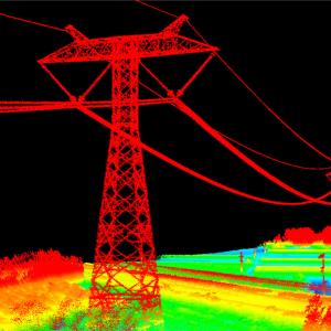
Drone LiDAR Scanning System GS-260X integrates Hesai XTM2X laser sensor, 26MP resolution camera and high accuracy POS to create a futuristic look for diversified LiDAR solution services.Stand out strong penetration and small beam, it can deliver a better performance in power line surveying compared with the same class uav LiDAR scanning system.

Specification of Drone LiDAR Scanning System GS-260X

Drone LiDAR scanning system gAirHawk GS-260X


Item Name

System Parameters


GS-260X

Parameters

Weight

1.15 kg

Measuring accuracy

Less than 0.1m/0.05m(@150m)

Working temperature

-20℃~+65℃

Power range

12V- 24V

Consumption

10W

Carrying Platform

GS-800, DJI M300, M600 PRO and Other brand

Storage

64GB storage, maximum support 128GB TF card

Lidar Unit


Measuring Range

80m@10% Reflectivity (Max 300m)

Laser class

905nm Class1 (IEC 60825-1:2014)

Channel

32-channel

Range accuracy

±1cm (typical Value)

Scanning frequency

10HZ, 20HZ

data

Trible-echo 1,920,000 Points/Sec

FOV

360°, adjustable

Laser sensor

HESAI Pandar XTM2X

POS Unit

Update frequency

200HZ

Heading accuracy

0.017°

Pitch accuracy

0.005°

Rolling accuracy

0.005°

Position accuracy

≤0.05m

GNSS signal type

GPSL1/L2/L5 GLONASSL1/L2 BDS B1/B2/B3 GAL E1/E5a/5b

Pre-processing software

POS software

Output information: position, speed, attitude

Point cloud software

Output point cloud data format: LAS format, custom TXT format

Camera

FOV

83 Degree

Effective Pixel

26 Mega Pixel

Focal Length(mm)

16


Application of Drone LiDAR Scanning System GS-260X


Free Trial Software Drone LiDAR Scanning System GS-260X
The Guideline of LiDAR Usage and Reference.pdf

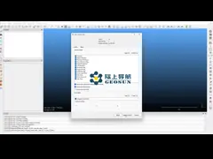
Point Cloud Pre-Processing Software Integrated With Trajectory Processing----Geosun Self-developed gAirHawk 5.0
Key Features of gAirHawk 5.0 Software
1. Raw data: intelligently load
2. Four default coordinates
3. Point cloud Optimization
4. Start and stop calculation
Free trial test, achieve high precision

Package of Drone LiDAR scanning system GS-260X
Drone LiDAR scanning system GS-260X is packed by suit case with EVA material liner inside, then covered by hard carton box.
The package of uav LiDAR scanning system is suitable for air shipment and sea shipment.


China 500kv Power Line Inspection Drone LiDAR Scanning System Geosun GS-260X PPK RTK Processing supplier

500kv Power Line Inspection Drone LiDAR Scanning System Geosun GS-260X PPK RTK Processing

Inquiry Cart 0