Product Details
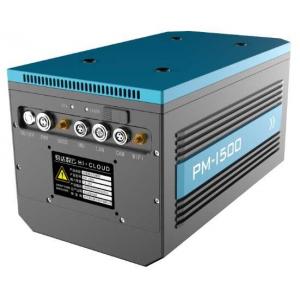
4.4kg 5mm@50m high precision 1500m@60% long range mobile LiDAR
system PM-1500 with 2million points/s frequency
Independently developed by Wuhan Hi-Cloud Technology Co.,Ltd., the
high-precision and long-range mobile LiDAR system PM-1500
integrates high-precision laser scanner, high-precision POS (GPS,
IMU) and other sensors based on a new generation of core technology
framework. The core component of the system is the laser scanner
with multi-echo technology function.
It can be applied to multi rotor UAV, VTOL fixed wing UAV, small
aircraft and helicopter to obtain dense high-precision laser point
cloud data on the ground on a fast flying mobile platform. It can
synchronously obtain 3D laser point cloud and POS data, quickly
generate DSM, DEM and DOM and produce DLG and 3D models through a
complete set of data processing and application software. The
system is widely used in new basic surveying and mapping, digital
3D modeling, topographic surveying and mapping, cadastral survey,
traffic survey, power line inspection, forestry survey, disaster
monitoring and other fields.
Parameter specification of mobile LiDAR system PM-1500
| Items | Indicators | Parameters |
| System Performance | Dimension | 293×165×164mm |
| Absolute Accuracy | horizontal <5cm |
| vertical <5cm |
| Weight | 4.4kg |
Multi Echo | 4 times |
| Temperature and Humidity | Operation: -40℃~60℃, Humidity 85% |
| Storage: -45℃~70℃, Humidity 85% |
| Items | Indicators | Parameters |
| Laser Scanner | Wave Band | Near Infrared (Class 1 ) |
| PRR | 100-2000Khz |
| Maximum Measurement Range | 1000m@20% reflectivity |
| 1500m@60% reflectivity |
| Range Accuracy | 5mm@50m |
| Angular Resolution | 0.001° |
| Scan Speed | 40-400 scans/s |
| FoV | 75° |
| Items | Indicators | Parameters |
| Camera | Camera Resolution | 42.4MP |
| Focal Length | 28mm |
| Items | Indicators | Parameters |
| POS System | Position Accuracy(post-processing) | Horizontal 0.01m |
| Elevation 0.02m |
| Orientation Accuracy(post-processing) | Heading 0.009° |
| Pitch/Roll 0.005° |
Main advantages of mobile LiDAR system PM-1500
1. High precision: The ranging accuracy of PM-1500 mobile LiDAR system can reach
5mm@50m, and the comprehensive accuracy of the system is better
than 5cm, meeting various high-precision application scenarios.
2. High frequency: The PM-1500 mobile LiDAR system with super high
frequency of up to 2 million points per second can be equipped with
UAV with faster cruising speed, and more data can be obtained in
the same time.
3. Long measurement range: The ultra long ranging of 1500 meters
greatly ensures the operation safety in the environment of large
topographic fluctuation.
4. Lightweight body: The overall weight of the system is less than
4.4kg. Even if you go out to work with UAVs and other accessories,
an ordinary vehicle can load all of them, which is very convenient.
5. Integration: The overall structure of PM-1500 airborne laser
measurement system has been innovatively optimized. It highly
integrates sensors such as laser scanner, GPS, IMU and aerial
survey camera, etc. It is lightweight and easy to install.
6. Multi echo technology: The PM-1500 mobile LiDAR system applies
multi echo technology. It can obtain up to 4 echo signals, and can
penetrate trees and feed back the most real surface information
even in densely vegetated areas.
Practical applications:
1. Topographic survey by PM-1500
2. Digital 3D city model by PM-1500
3. Inspection of 500kV DC transmission line by PM-1500
Company Profile
Hi-Cloud -- the leader of 3D laser scanning technology
Wuhan Hi-Cloud Technology Co.,Ltd. founded in 2012, and is a
holding company of Guangzhou Hi-Target Satellite Navigation
Technology Co.,Ltd (stock code: 300177) with more than 200 team
members and a product service network covering the whole country.
Hi-Cloud has been committed to the development, application service
and industrialization of high-precision 3D laser series products
for long term. It has taken the lead in overcoming the key core
technology of full waveform LiDAR, breaking the long-term monopoly
of foreign technology. It has formed a full series of product line
layout of 3D laser "sea, land and air", and is far ahead in the
application field of high-precision of domestic equipment. It is
one of the few 3D laser solution providers in China that fully
master the core technology of LiDAR and realize industrialization.
Products and technologies are widely used in geographic information
surveying and mapping , digital city, industrial digitization and
other fields to provide technical support for the construction and
application of digital 3D world.
Hi-Cloud has applied for and owned 105 patents, 48 software
copyrights, won a number of provincial and ministerial scientific
and technological progress awards, won the title of "Gazelle
Enterprise" in Wuhan East Lake Hi-Tech District for six consecutive
years, and has been successively rated as a “High-Tech Enterprise”,
Hubei enterprise technology center, an "Invisible Champion" in
market segments, and "Little Giant" enterprise in Hubei Province.
In the future, Hi-Cloud will always adhere to the localization of
high-end equipment as its own responsibility, and continue to
promote the industrialization of domestic high-precision LiDAR,
committed to become a global leader of 3Dlaser scanning technology.