
Add to Cart
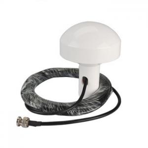
External Furuno GP32 GPS antenna Receiver
with 6 Meter Cable TNC for Furuno GP32 GP35 GP36 GP37
| Technical Details: | |
| Frequency Range: | 1575±5MHz |
| Voltage: | 3~5V |
| Amplifier Gain: | 26dB |
| Antenna Gain.: | 3.5dBic |
| LNA Gain: | 28 dB typ. |
| Noise Figure: | 1.5dB typ. |
| Operating Temperature(Deg.C) | -45~+85 |
| Storage Temperature(Deg.C) | -50~+90 |
| Humidity: | 100% |
| Weatherproof: | Yes |
| Length: | 6 m |
| Color: | White |
1. What is Marine GPS?
A marine global positioning system (GPS) is a navigational system which is designed specifically for marine environments. Several companies make marine GPS products which vary in size and sophistication. These devices are strongly recommended for navigators because they increase safety on the open ocean and many people receive training in how to use a GPS when they are learning to sail.
A basic marine GPS system may be handheld, designed to mount onto an instrument panel, or integrated directly into the instrument panel of the ship. By communicating with satellites, it can determine the direction and speed of the ship, and this information is relayed on the screen. Marine GPS is often integrated with a chartplotter program so that the course of the ship can be plotted electronically and the GPS can be used to monitor how closely the ship is sticking to the plotted course.
People can use GPS just for taking positional fixes to determine where they are in the open ocean, or to confirm positional fixes taken by other means. However, the full functionality of marine GPS offers many additional features and people are often advised to take advantage of them. Chartplotting can be useful, as can the use of a GPS transponder which can signal the ship's position to another location so that in the event of a problem, rescuers know where to go.

