
Add to Cart
HXN1-Y 25~30m/s Cruising Speed 90minute Endurance Industrial UAV 3D Mining Urban Modeling Surveying Aerial Mapping Drone
When the multi-rotor UAV HXN1-Y series is in a low voltage state or a signal loss state, it will automatically trigger the Return to Launch failsafe to save the situation.
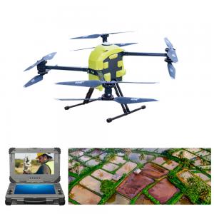
The bottom of the 8-rotor UAV has a variety of interfaces, mechanical quick-release parts, and can support single-light, double-light, three-light pods, megaphones, high beams, logistics delivery boxes, throwing boxes, steering gear gimbals, orthographic Cameras, oblique photography, 100-megapixel mapping cameras, lidar systems, multi-spectral, hyperspectral, and other mounting systems.
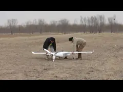
The flexible and flexible design of the folding body makes the operation easy. Even in unknown areas, HXN1-Y can use various professional surveying and mapping cameras to collect geographic information and generate accurate orthophotos or 3D maps without being limited by geographic terrain.
Accurate horizontal positioning within 1cm error can be achieved, which can make your work more outstanding.
Clear setup steps make it easy for anyone to master. After connecting PC via WiFi/BT/USB on MissionPlanner/PC, industrial multi-rotor UAV flight becomes programmable.
Forged from a combination of carbon fiber, PCB and CNC, the drone is strong and durable, and can perform flight tasks in a wide temperature range of -10°C-55°C.
HXN1-Y has a built-in 14S 14000mAh high-voltage lithium-ion battery, and the no-load flight time has been increased to 90 minutes, and it can still reach 45 minutes with a 2.5kg load.
The multi-rotor drone has a built-in set of antenna shields to prevent dust and moisture. Self-locking propellers install without tools.
Herelink can also be used as a streaming server to transmit video and data (WAN) between team members through devices such as Ipads, mobile phones or PCs, so that the team can participate in tasks at the same time.
There is a navigation light system on the motor base, with three modes of exhalation flash, flash, and light off, and the navigation light effect can be used in different flight environments
HXN1-Y is a powerful drone aerial photography platform for surveying, surveillance, police and inspection.
HXN1-Y is a type of multi-rotor UAV. With its 90-minute battery life, centimeter-level positioning capabilities, IP65 rating, folding frame, and multiple failsafe features, it also packs utility into a tiny body.
HXN1-Y Specification Aerial Mapping Drone | |
|---|---|
| Drone Version | HXN1-Y |
| Drone Material | Carbon Fiber, CNC, PCB |
| Drone Max Speed | 30m/s |
| Drone Max Lifting Speed | 4m/s |
| Drone Max Descent Speed | 3m/s |
| Drone Max Take-off Weight | 15kg |
| Working Voltage | 48V |
| Working Temperature | -10℃-55℃ |
| Carrying Case | 68cm*45cm*35cm |
| Hovering Precision | Vertical±0.2m; Horizontal±0.1m (no RTK) |
| Horizontal Positioning Accuracy | 0.01m+1ppm CEP(RTK) |
| Flight Time | 80min (no payload) |
| 68min (800g payload) | |
| 45min (2500g payload) | |
| Camera | 4K, HD, Thermal imaging |
| Controller | Herelink 2.4GHz Long Range HD Video Transmission System |
| IP Rating | IP65 |
| Service Ceiling | 6000m |
| Max Angle of Pitch | 25° |
| Wind Resistance | 14m/s |
| Unfolded Dimensions | 670*650*200mm (excluding propellers/landing gears) |
| Folded Dimensions | 440*210*200mm (excluding propellers/landing gears) |
| Diagonal Wheelbase | 815mm |
| Empty Weight | 5.4kg (including battery) |
| Battery Weight | 2.8kg |
| Max Take-off Weight | 15kg |
Purchasing FAQ?
1. Can I test a sample Aerial Mapping Drone with sample custom features?
Yes, we support sample testing.
Please tell us your needs and application scenarios, and we will recommend different solutions to discuss with you.
2. Can I create my own drone brand?
Yes, we can realize customizing your brand logo on drone operating system, drone body, accessories, packaging.
3. How can you ship to my country?
[DAP Mode - International Express] Usually it only takes 3~6 days, and the buyer pays the import duties.
[DDP Mode - Air Freight] Usually it only takes 12~16 days, that is, we help you prepay the import duties of your country, and you sign for the goods directly after they pass the customs.
4. Do you provide warranty?
Yes, if the product has quality problems within 1 year, we can provide free repair or replacement of spare parts.
5. Do you provide technical services?
Yes, all of our products come with free technical guidance, with installation instruction and operation video & PDF.