
Aeromapper Talon UAV Drone Industrial Aircraft Mapping Inspection Agricultural Transport Description The Aeromapper Talon is our best-selling fixed-wi...
Add to Cart
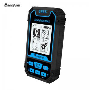
Real Time Map GPS Land Measuring Instrument Outdoor Survey Instrument Land Area Meter Main Features and Benefits: It measures the length, width and ar...
Add to Cart

PQWT-S500 Automatic Mapping Portable Underground Water Detector Machine/Reliable Long Range Groundwater Seeker Detection 【Geophysical Exploration Tech...
Add to Cart
Product Key Features of Drone Video Transmitter: Model:CD15NMT-mini Range:15km Weight:Tx 110g Rx 110g Dimension:88x55x17mm Video&Data:IP Ethernet ...
Add to Cart
Product Description: Application: Car navigation and traffic recorder. Drones and law enforcement cameras. HD cameras for surveying and mapping purpos...
Add to Cart