
UAV Drone Surveillance Mapping Fixed Wing Professional Industrial Aircraft Description Lightweight regulatory compliant mapping drone Designed to prov...
Add to Cart
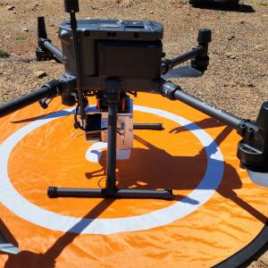
Land Mapping Drone LiDAR Mapping 3D Scanning Accuractely Capture Demonstration In Australia Geosun gAirHawk Series Drone LiDAR Scanning System GS-130X...
Add to Cart

HXN1-R 80minute Flight Time 15kg Take-Off Weight Surveying Mapping Security Payload 3KG UAV 8 Rotor Industrial Drone HXN1-R is a small drone aerial ph...
Add to Cart
Product Description FLYIN Factory 3LCD 3D Laser Projecto 10000 Lumens 4K Proyector 3D Mapping For Large Scene Digital Cinema 3 LCD Large Venue Project...
Add to Cart
High Brightness 3D Mapping Laser Projector 20000 Lumens Experience unparalleled clarity and brightness with the SMX MX-X2000 Laser Projector. Boasting...
Add to Cart
3D Mapping projection technology supports arbitrary layout of projectors to meet the fit of various objects. Using 3D mipping projection technology, t...
Add to Cart
Vietnam 3D Mapping Show Fountain Project Project Name: Vietnam 3D Mapping Show Fountain A three-dimensional image formed by the interference of light ...
Add to Cart
Product Key Features of Drone Video Transmitter: Model:CD15NMT-mini Range:15km Weight:Tx 110g Rx 110g Dimension:88x55x17mm Video&Data:IP Ethernet ...
Add to Cart
Tesla Style Lexus Android Head Unit 3D Maps GPS Car Radio Stereo 11.8 Inch Car Stereo Sat Nav For Lexus RX 2004-2007 Tesla Style Big Screen Android 9 ...
Add to Cart
SMX Outdoor Large Venue 3LCD 4k 20000 Lumen Laser Projector , Building 3D Mapping Projector Overview – Brightness 20,000 lumens . With a series of com...
Add to Cart
3d Map Luggage Auto Parts Blister PVC ABS Acrylic Plastic Vacuum Molding Machine (Model:PE-1400) ★ Product Introduction of vacuum forming machine : Bl...
Add to Cart
ARS-200 UAV mapping system LiDAR with 100000 points/s frequency and 15mm accuracy which only 2.5kg weight The Riegl LiDAR based UAV mapping system ARS...
Add to Cart
Newly Upgraded Laser Scanner CHCNAV AlphaAir 450 Integrated Multi-Sensor UAV Surveying System Product Descriptin X1 quadrotor flight platform is a por...
Add to Cart
WhatsApp:+86 151 2090 9824 1. Products independently developed by the incubator (non-standard customization). 2. The products of this incubator are ma...
Add to Cart
GODO Remote Management System Key Features Digital Twin and Video AR Fusion Based on 3D live model and satellite map, combined with actual parameters ...
Add to Cart
UAV Mapping Drone Foldable Six Rotor Oil Electricity Hybrid Mapping UAV drone XQL12 Series Foldable Six Rotor Oil Electricity Hybrid Mapping UAV drone...
Add to Cart
2.4G 5.8G UAV Aerial Photography Map Transmission Drone Receiver Antenna 5G 5.8G UAV aerial photography map transmission mapping model aerial data tra...
Add to Cart
Product Description: Tethered Drone Station Product Overview The Tethered Drone Station is an innovative and versatile product designed for aerial map...
Add to Cart
DJI Agras T40 Function Headless mode, Altitude Hold Mode, 3D View Mode, With Camera, with G-sensor, 3D flip, One Key Takeoff / Landing, APP Control, V...
Add to Cart