... Equipment Refraction Equipment What equipment is used in ? WZG-48C Equipment WZG-24C Su...
Add to Cart

Geophone Element 2Hz Vertical / Horizontal The geophone 2hz (EG-2-I) is mainly used for deep , advanced forecasting, natural seismic sur...
Add to Cart

... Equipment High-resolution seismographs can use hammering, electric sparks or explosions as excitation sources. The depth of explorat...
Add to Cart
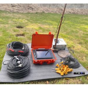
... farmland and so on complex area carries on the petroleum, the geological mine well drilling construction, best working conditions t...
Add to Cart
Main Application: Building base, roadbed and foundation engineering detection Cavity survey, cavern survey Quaternary overburden layer delamination Fo...
Add to Cart
5mm@40m accuracy 1.5m to 650m range 500kHz IP64 protection HS650i high frequency 3D laser scanner for volume calculation Earthwork is an important par...
Add to Cart
... ★ With Hard-Soft Magnetic And Tilt Compensation ★ RS232/RS485/TTL ▶ APPLICATION ★ Satellite Antenna Search Satellite ★ Marine Navigation ...
Add to Cart
Revolutionize Your with Imaging Geophysical Equipment Product Description: 300m natural electric field a key to mapping geophysica...
Add to Cart
Product Description: V700S New Generation Engineering Surveying System The V700S combines cutting-edge RTK and SLAM technologies to provide centimeter...
Add to Cart
... Laser Scanner Battery , best selling equipment accessories Features 1. Our batteries are manufactured with top quality Germany cells u...
Add to Cart
... 1.4Hours Endurance UAV Camera Mining Urban Modeling Aerial Mapping Drone ⇨Foldable Body The flexible and flexible design of the foldin...
Add to Cart
Smart City Application UAV LiDAR System Geosun GS-130X 3D Surveying And Mapping Hesai XT32 Sensor Applications Of uav LiDAR Scanning System Specificat...
Add to Cart
Product Description Monitoring 360° Prism Total Station Copper coated prisms with six planes mounted in an ABS frame, Leica Style Tip Adapte...
Add to Cart
...designed for autonomous underwater vehicles (AUVs), submersibles, and vessels. Featuring advanced phased-array transducer technology, it pro...
Add to Cart
Topcon 3D MC GPS GNSS RTK Machine Control Grader Dozer Paver Excavator Complete set This system has been tested and is in great working condition. 3DM...
Add to Cart
Customized Square Sectional Modular GRP FRP SMC Panel Water Storage Tank SMC GRP FRP Storage Water Tank application: 1. Storage and regulation of livi...
Add to Cart
3D Scan Measuring Black and White Target Reflector with Magnet Base Model: ADSmini108-2 Overview: A. 6" circular black/white tilt &turn target for Sca...
Add to Cart
... standards (AISC, EN, GB), including wind and calculations. BIM Modeling & Coordination: Utilize Revit, Tekla, and other software for /BI...
Add to Cart
... used. Main Features: 1. Instrument equipped with RS - 232 interface, after connect with computer, using special measuring software M2D of surveyin...
Add to Cart
Product Description: Our steel warehouse is designed with a portal frame structure, which ensures simple force and a clear force transmission path. Th...
Add to Cart