Multi Rotor LiDAR Drone Safety Aircraft Aerial Survey Operation
Support
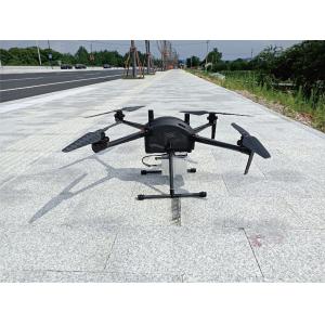
GS-800 multi-rotor UAV aerial photographing and mapping system is
made of high-strength carbon fiber, with
novel and lightweight fuselage design, smart, stable, flexible, and
low noise. It supports simulated flight, long
flight time, suitable for operation in cities, towns and
mountainous areas.
GS-800 multi-rotor UAV aerial photographing and mapping system,
simple to operate and convenient to
transport, can carry out simple and stable flight without too much
technical training. It is widely used in geological exploration,
remote sensing mapping, environmental protection, meteorological
exploration, disaster monitoring, aerial survey, line and pipeline
inspection, urban patrol and so on.
Application
Small and medium-sized mapping, aerial mapping, aerial monitoring,
power planning and design, land survey,
forestry application, earthquake relief and other industries.
High Efficiency
Endurance without payload ≤ 85mins Endurance with GS-100M+ ≤ 65mins
Endurance with GS-00C+≤ 50mins Endurance with GS-30X/GS-260X≤
40mins
Easy Operation
Support simulated flight and adapt to mountain operation
Support to import KML and accurately plan the survey area
Automatic figure 8 flight, coordinated turn
Aircraft self inspection protection and pre flight inspection
protection to avoid misoperation
Automatic return with low power, automatic return with broken chain
and no fly zone are set to
reduce potential safety hazards
Magnetic compass abnormal protection, attitude protection and
broken propeller protection
provide escort for safe operation
Technical Parameter
| |
| Standard payload (Kg) | 5 |
| Max. Payload (Kg) | 2.5 |
| Cruise speed (m/s) | 0-15 |
| MTOW (Kg) | 20 |
| Battery (V, mAh) | 14S 14000mAh × 1 |
| Working temperature | 20~45℃ |
| Wheelbase (mm) | 815 |
| Duration of flight (Minutes) | > 40 |
| Max. Duration (Minutes) | > 60 |
| Max. Fly height (m) | 5000 |
| Wind Resistance Wind Velocity | 6 |
| Differential mode Support | RTK/PPK |
| Package size (mm) | 663×496×338 |
Application for Mapping & Survey
Package Information