
Add to Cart
920m@60% range 15mm@150m range accuracy 4.5kg ARS-1000 Lightweight UAV Mapping System with 10~200 scans/s scan speed
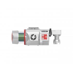
ARS-1000 Lightweight UAV Mapping System is a Riegl LiDAR based airborne LiDAR system. The whole system is developed and built by Wuhan Hi-Cloud Technology Co.,Ltd. It integrates different sensors like high-precision laser, high-definition camera, GPS, MEMS inertial navigation and storage control unit. Supported by time synchronization technology of independent intellectual property and integrated multi-sensor integration technology, it can synchronously obtain 3D laser point cloud, POS data and also image data. The system has the advantages of light weight, convenient transportation and high efficiency of results processing. It can be widely used in emergency mapping, topographic mapping, power line inspection, highway survey, coastal reef survey, excavation and filling calculation, archaeological survey and mapping and other fields.
Specification
ARS-1000 Lightweight UAV Mapping System
| Items | Parameters | ||
| System Performance | Absolute Accuracy | ±5cm | |
| Weight | 4.5kg | ||
| Operation Mode | Airborne/Vehicle mounted/Backpack | ||
| Laser Scanning Unit | Laser Classification | Class 1 | |
| Max. Measurement Range | 920m@60% | ||
| Max. Effective Scan Speed | 500,000points/s | ||
| Data Update Rate | 200Hz | ||
| FoV | 330° | ||
| Angular Resolution | 0.001° | ||
| Multi-echo Function | Available | ||
| INS | Position Accuracy (post-processing) | Horizontal | 0.01m |
| Elevation | 0.02m | ||
| Heading Accuracy | 0.010° | ||
| Pitch/roll Accuracy | 0.005° | ||
Features
Application of Highway survey project
1. Project Overview:
The terrain of the survey area is complex, the vegetation is lush and the altitude difference is large. Two highways need to be measured, with a total length of about 60km.
2. Project Requirement and Difficulties:
Be responsible for the vertical and horizontal section measurement of 100 meters (200 meters of bandwidth) on both sides of the middle line of the road according to the relevant standards, technical specifications and procedures, and the output results shall be in accordance with the 1:500 mapping requirements.
Due to the high mountains, rough roads, lush vegetation and dense traffic on the highway, the task of field survey is dangerous.
3. Solution
According to the specific situation of the project, ARS-1000 Lightweight UAV Mapping System is adopted to collect flight data along the road according to the relative altitude of 200m.


