Product Details
Product Description:
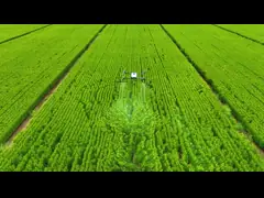
Aerial Photography Uav is an advanced aerial drone and video
platform designed for aerial photography, and aerial video
creation. This powerful unmanned aerial vehicle (UAV) has an
impressive range with a maximum chart pass distance of 30M,
two-axis gimbal, GPS/GLONASS satellite positioning systems and a
foldable wheelbase with a 1800 Mah battery for extended flight
times. It is an excellent choice for UAV airborne photography and
aerial .
Features:
- Product Name: Aerial Photography Uav
- Remote Control Distance: 200M
- Chart Pass Distance: 30M
- Battery: 1800 Mah
- Gimbal: Two Axis
- Satellite Positioning Systems: GPS/GLONASS
- Aerial Drone
- Unmanned Aerial Photography
- Remote Controlled Aircraft
Technical Parameters:
| Satellite Positioning Systems | GPS/GLONASS |
|---|
| Remote Control Distance | 200M |
|---|
| Battery | 1800 Mah |
|---|
| Wheelbase | Foldable |
|---|
| Chart Pass Distance | 30M |
|---|
| Gimbal | Two Axis |
|---|
Applications:
Aerial Photography UAV is equipped with a Model Number V162 made in
China, with a minimum order quantity of 1 pcs and a negotiable
price. It is packaged in standard packages and has a delivery time
of 3-7 work days with payment terms of L/C, D/A, D/P, T/T, Western
Union. It has a supply ability of 100,000 pcs per month. The Chart
Pass Distance is 30M and the Remote Control Distance is 200M. It is
powered by a 1800 Mah Battery and has a foldable Wheelbase. It is
equipped with GPS/GLONASS Satellite Positioning Systems.
Aerial Photography UAV is ideal for drone photo system, UAV
airborne photography and aerial imaging device. It is used by
professional photographers, filmmakers, surveyors and other
experts. It has a chart pass distance of 30M and a remote control
distance of 200M. It is powered by a 1800 Mah battery and has a
foldable wheelbase. It is equipped with GPS/GLONASS satellite
positioning systems which enables high precision and accuracy. It
is also perfect for aerial , , cinematography, photography and
inspections.
Customization:
Customized Aerial Photography UAV
Our Aerial Photography UAV offers comprehensive UAV solutions for
aerial and photography. Model V162 is equipped with two axis gimbal
and foldable wheelbase for better stability and portability. It has
a remote control distance of up to 200M and chart pass distance of
30M. This UAV also has a 1800 Mah battery to power it up.
Key Feature
- Unmanned Aerial Vehicle
- Aerial Drone
- Unmanned Aerial Photography
- Foldable Wheelbase
- Two Axis Gimbal
- 1800 Mah Battery
Product Specifications
- Model Number: V162
- Place of Origin: China
- Minimum Order Quantity: 1 Pcs
- Price: Negotiable
- Packaging Details: Standard Packages
- Delivery Time: 3-7 work days
- Payment Terms: L/C, D/A, D/P, T/T, Western Union
- Supply Ability: 100,000 pcs per month
- Remote Control Distance: 200M
- Wheelbase: Foldable
- Gimbal: Two Axis
- Chart Pass Distance: 30M
- Battery: 1800 Mah
FAQ:
- Q: What is the model number of the Aerial Photography Uav?
- A: The model number of the Aerial Photography Uav is V162.
- Q: Where is the Aerial Photography Uav produced?
- A: The Aerial Photography Uav is produced in China.
- Q: What is the minimum order quantity for the Aerial Photography
Uav?
- A: The minimum order quantity for the Aerial Photography Uav is 1
Pcs.
- Q: How much is the Aerial Photography Uav?
- A: The price for the Aerial Photography Uav is negotiable.
- Q: How is the Aerial Photography Uav packaged?
- A: The Aerial Photography Uav is packaged in standard packages.
Company Profile
Hong Kong Global Intelligence Technology Group Limited is a
high-tech enterprise integrating R&D, production, and sales of
military, police, and civilian drones.
In response to national strategies and calls, and to cope with
fluctuations in the foreign political environment, Hong Kong Global
Intelligence Technology Group and its subsidiaries jointly
participated in the strategic planning of the intelligent industry
development of government projects and carried out the construction
of new economic and industrial infrastructure, taking the
construction of low-altitude economic industrial parks as the core
is to focus on new models and new business formats of the drone
industry, promote military-civilian integration, and develop and
support military.