Aerial 3D Mapping Drones Foldable for Land Surveying
Brand Name:ZAi
Certification:CE ROHS FCC SGS
Model Number:Faith mini
Minimum Order Quantity:1000
Delivery Time:sample3-5 days, 30 days around for mass order
Payment Terms:L/C, D/A, D/P, T/T, Western Union
Contact Now
Add to Cart
Verified Supplier
Location:
Hong kong China
Address:
ROOM A1, 11/F WINNER BUILDING, 36 MAN YUE STREET, HUNG HOM, KOWLOON, HONG KONG
Supplier`s last login times:
within 30 hours
Shipping
lt's easy to get a shipping quote! Just click the button below and complete the short form.
Get Shipping Quote
Product Details
Company Profile
Product Details
Product Description:
Three-Dimension-Mapping-Drones are advanced aerial robots designed to capture data of the world around them. The drones are equipped with flight control systems that are compatible with the Mavlink Protocol Flight Control, a 2100mAh battery, a maximum ascend speed of 5m/s, a foldable 600mm wheelbase, and a camera that takes JPEG photos. These features make Three-Dimension-Mapping-Drones ideal for surveying and mapping a wide range of areas, providing detailed and accurate three-dimensional maps of the terrain. Three-Dimension-Mapping-Drones are reliable, efficient, and easy to use, giving you the ability to quickly and accurately capture data for whatever project you're undertaking.
Features:
- Product Name: 3D Mapping Drones
- Gimbal: 3-axis
- 4G Extended Image Transmission: Global 4G Image Transmission, Unlimited Distance
- Maximum Ascend Speed: 5m/s
- Satellite Positioning Systems: GPS/GLONASS
- Wheelbase: 600mm,foldable
- Features: Remotely-Operated-UAV-Mapping, Aerial-Photogrammetry-Mapping-Drones
Technical Parameters:
| Parameter | Details |
|---|---|
| Product | Remotely-Operated-UAV-Mapping, High-Resolution-Surveying-Drones, Geographic-Information-System-Drones |
| Photo | JPEG |
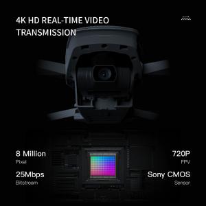
| Image Size | 3840*2160 |
| Maximum Decsend Speed | 4m/s |
| Maximum Ascend Speed | 5m/s |
| Maximum Distance | 1080P 10km |
| Max Service Ceiling Above Sea Level | 5000m |
| Flight Time | 40mins(no Load) ,29mins(full Load) |
| Wheelbase | 600mm,foldable |
| Battery | 2100mAh |
| Satellite Positioning Systems | GPS/GLONASS |
Applications:
3D Mapping Drones, Faith mini, is a China-origin drone specifically designed for three-dimension mapping. With its maximum decsend speed of 4m/s, Flight time of 40 minutes (no load) and 29 minutes (full load), battery of 2100mAh, and satellite positioning systems of GPS/GLONASS, this drone is the perfect choice for three-dimension mapping. It also has a maximum ascend speed of 5m/s, making it a reliable and efficient tool for mapping. With a minimum order quantity of one piece, price that is negotiable, and standard packages for delivery, this 3D Mapping Drones, Faith mini is the ideal drone for three-dimension mapping. It is also capable of providing up to 100,000 pcs per month, with delivery time of 3-7 work days and payment terms of L/C, D/A, D/P, T/T, Western Union.
Customization:
Customized 3D Mapping Drones
We offer customized 3D Mapping Drones, with Model Number Faith mini, Place of Origin China, Minimum Order Quantity 1 Pcs, Price Negotiatial, Packaging Details Standard Packages, Delivery Time 3-7 work days, Payment Terms L/C, D/A, D/P, T/T, Western Union, Supply Ability 100,000 pcs per month, Gimbal 3-axis, Max Service Ceiling Above Sea Level 5000m, Maximum Decsend Speed 4m/s, Photo JPEG, Operating Temperature Range -5-40℃.
Our Topographical-Mapping-Drones, 3D-Mapping-Drones and Remotely-Operated-UAV-Mapping-Platforms are of high quality and provide a reliable mapping solution.
FAQ:
Q1: What is the model number of the 3D Mapping Drones?
A1: The model number of the 3D Mapping Drones is Faith mini.
Q2: Where is the 3D Mapping Drones made?
A2: The 3D Mapping Drones is made in China.
Q3: What is the minimum order quantity?
A3: The minimum order quantity is 1 Pcs.
Q4: What is the price?
A4: The price is negotiable.
Q5: What is the packaging detail and delivery time?
A5: The packaging detail is standard packages, and the delivery time is 3-7 work days.


Aerial 3D Mapping Drones Foldable for Land Surveying
Inquiry Cart
0