Mapping And Surveying Drones , Professional Drones For Surveying
Brand Name:ZAi
Certification:CE ROHS FCC SGS
Model Number:Faith mini
Minimum Order Quantity:1000
Delivery Time:sample3-5 days, 30 days around for mass order
Payment Terms:L/C, D/A, D/P, T/T, Western Union
Contact Now
Add to Cart
Verified Supplier
Location:
Hong kong China
Address:
ROOM A1, 11/F WINNER BUILDING, 36 MAN YUE STREET, HUNG HOM, KOWLOON, HONG KONG
Supplier`s last login times:
within 30 hours
Shipping
lt's easy to get a shipping quote! Just click the button below and complete the short form.
Get Shipping Quote
Product Details
Company Profile
Product Details
Product Description:
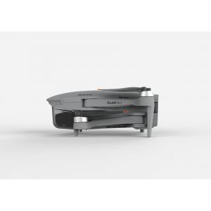
3D Mapping Drones are remotely-operated-UAV-mapping machines designed for autonomous-drone-surveying operations. With a 600mm wheelbase and a foldable design, 3D Mapping Drones offer high mobility and compactness. They come equipped with a 3-axis gimbal, as well as GPS/GLONASS satellite positioning systems for accurate positioning and navigation. Global 4G image transmission allows for unlimited distance image transmission, and users can enjoy 1080P high-definition images up to 10km away. 3D Mapping Drones are versatile unmanned-aerial-vehicles-mapping solutions that can be used in a variety of surveying scenarios.
Features:
- Remotely-Operated-UAV-Mapping: 3D Mapping Drones are remotely operated UAVs which are used for mapping and surveying.
- Flight Control: 3D Mapping Drones are compatible with Mavlink Protocol Flight Control.
- Max Service Ceiling Above Sea Level: 3D Mapping Drones have a maximum service ceiling of 5000m above sea level.
- Maximum Decsend Speed: 3D Mapping Drones have a maximum descend speed of 4m/s.
- Maximum Distance: 3D Mapping Drones have a maximum distance of 1080P 10km.
- Flight Time: 3D Mapping Drones have a flight time of 40 minutes (no load) and 29 minutes (full load).
- Autonomous-Drone-Surveying: 3D Mapping Drones are used for autonomous drone surveying.
Technical Parameters:
| Features | Specifications |
|---|---|
| Battery | 2100mAh |
| Satellite Positioning Systems | GPS/GLONASS |
| Maximum Distance | 1080P 10km |
| Max Service Ceiling Above Sea Level | 5000m |
| Maximum Ascend Speed | 5m/s |
| Gimbal | 3-axis |
| Photo | JPEG |
| Operating Temperature Range | -5-40℃ |
| Flight Time | 40mins(no Load),29mins(full Load) |
| Flight Control | Compatible With Mavlink Protocol Flight Control |
| Remotely-Operated-UAV-Mapping | Yes |
| Autonomous-Drone-Surveying | Yes |
Applications:
3D Mapping Drones, which model Faith mini, is made in China with a minimum order quantity of 1 Pcs and a negotiable price. It is packaged in standard packages and can be delivered within 3-7 work days after payment. The payment terms include L/C, D/A, D/P, T/T, Western Union, and the supply ability is 100,000 pcs per month. It has a satellite positioning systems of GPS/GLONASS, a max service ceiling above sea level of 5000m, a flight time of 40mins(no load) and 29mins(full load), and an operating temperature range of -5-40℃. Its flight control is compatible with Mavlink Protocol Flight Control.
3D Mapping Drones has a variety of applications and scenarios. It is widely used in Geographic-Information-System-Drones, which helps to capture and analyze the data of geographic features such as roads, buildings, rivers and more. It can also be used in High-Resolution-Surveying-Drones for measuring and analyzing the terrain to generate survey maps. In addition, it can be used for Robotic-Mapping-Aircrafts, which can be used in aerial photogrammetry, topography, and 3D modeling.
Customization:
We offer high-resolution surveying drones, topographical mapping drones, and robotic mapping aircrafts. Our Faith mini 3D mapping drones are the perfect solution for any mapping project. With a wheelbase of 600mm, they are foldable for easy storage and portability. The maximum distance is 1080P 10km, and the flight time is 40mins(no load) and 29mins (full load). With GPS/GLONASS satellite positioning systems, the Faith mini can take high-quality photos in JPEG format. The minimum order quantity is 1 pc, and the price is negotiable. Standard packages are available for delivery, with 3-7 work days. Payment options include L/C, D/A, D/P, T/T, and Western Union. Our supply ability is 100,000 pcs per month.
FAQ:
3D Mapping Drones
Q: What is the Model Number of this product?
A: The Model Number of this product is Faith mini.
Q: Where is this product from?
A: This product is from China.
Q: What is the minimum order quantity?
A: The minimum order quantity is 1 Pcs.
Q: What kind of payments can I use for this product?
A: You can use L/C, D/A, D/P, T/T, Western Union for this product.
Q: How long will it take to deliver this product?
A: It will take 3-7 work days to deliver this product.


Mapping And Surveying Drones , Professional Drones For Surveying
Inquiry Cart
0