
Add to Cart
GPS navigation sensor high precise inertial sensor with GPS
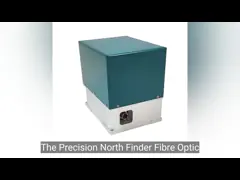
INS500 fiber integrated navigation system (the "ins") by the closed loop based on high precision fiber optic gyro, accelerometer and high-end GNSS receiver boards, navigation through multiple sensor fusion and decoding algorithm, provide high precision navigation position, velocity and position information, such as meet the requirement of high precision measurement and control, and main application fields include: The system has inertial/satellite integrated navigation mode and pure inertial mode.
When GNSS is invalid, it can enter the pure inertia mode (that is, GPS fusion has never been carried out after power is turned on, if the fusion is lost again, it belongs to the integrated navigation mode). After starting, it has accurate attitude measurement function, can output pitch roll course, and pure inertia can static north search.
| Items | Test Conditions | A0Indicators | B0Indicators |
| Positioning accuracy | GNSSValid, single point | 1.2m(RMS) | 1.2m(RMS) |
| GNSSValid,RTK | 2cm+1ppm(RMS) | 2cm+1ppm(RMS) | |
| Position holding (GNSS failure) | 1.5nm/h(50%CEP),5nm/2h(50%CEP) | 0.8nm/h(CEP),3.0nm/3h(CEP) | |
| Heading accuracy | North-seekingit self | 0.1°×sec(Lati), *Lati:latitude (RMS),10min | 0.06°×sec(Lati),Static base 5min alignment; 0.03°×sec(Lati),Static base 5min alignment;*Lati:latitude (RMS) |
| Course keeping (GNSS failure) | 0.05°/h(RMS),0.1°/2h(RMS) | 0.02°/h(RMS),0.05°/3h(RMS) | |
| Attitude accuracy | GNSS Valid | 0.03°(RMS) | 0.01°(RMS) |
| Attitude holding (GNSS failure) | 0.02°/h(RMS),0.06°/2h(RMS) | 0.01°/h(RMS),0.03°/3h(RMS) | |
| Speed accuracy | GNSS Valid, single pointL1/L2 | 0.1m/s(RMS) | 0.1m/s(RMS) |
| Speed retention (GNSS failure) | 2m/s/h(RMS),5m/s/2h(RMS) | 0.8m/s/h(RMS),3m/s/3h(RMS) | |
| Fiber optical gyro | Measuring range | ±400°/s | ±400°/s |
| Bias stability | ≤0.02°/h | ≤0.01°/h | |
| Quartz flexibleaccelerometer | Measuring range | ±20g | ±20g |
| Bias stability | ≤50µg(10s Average) | ≤20µg(10s平均) | |
| Communication interface | RS422 | 6waysThe baud rate ranges from 9.6 KBPS to 921.6 KBPS. The default baud rate is 115.2 KBPSThe maximum frequency is 1000Hz(raw data), and the default frequency is 200Hz | |
| RS232 | 1 wayThe baud rate ranges from 9.6 KBPS to 921.6 KBPS. The default baud rate is 115.2 KBPSThe maximum frequency is 1000Hz(raw data), and the default frequency is 200Hz | ||
| Electrical characteristics | Voltage | 24~36VDC | |
| Power consumption | ≤30W | ||
| Structural characteristics | Dimension | 199mm×180mm×219.5mm | |
| Weight | 6.5kg | ≤7.5kg(non-aviation)≤6.5kg (aviation optional) | |
| Environment | Working temperature | -40℃~+60℃ | |
| Storage temperature | -45℃~+65℃ | ||
| Vibration (with damping) | 5~2000Hz,6.06g | ||
| Impact (with shock absorption) | 30g,11ms | ||
| Reliability | Lifetime | >15years | |
| Continuous working time | >24h | ||