
Add to Cart
HX4HFW460 VTOL 3D 4D Urban Modeling Surveying Aerial Mapping Drone Fully Automatic Driving Fixed Wing UAV Camera
Oil-powered fixed-wing UAV Features Description
Motion Measurement
High-precision and high-dynamic motion measurement
High Security
Oil-driven active power provides a higher safety factor
Set emergency landing and parachute double protection
Oil-driven fixed-wing UAV application field
Aerial survey, police patrol, forest fire prevention, aerial
surveying and mapping, power pipeline line-finding, environmental
protection detection, disaster detection, aerial law enforcement,
road and railway hydraulic measurement, 3D imaging, etc.
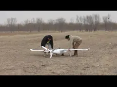
Industrial Drone with fully autonomous flying VTOL
One-key take-off, safe and efficient
Without operator intervention, the UAV automatically completes task
cruise, flight state transition, vertical take-off and landing
Autopilot
Full coverage of models with centimeter-level positioning accuracy
Satellite Navigation
Real-time differential GPS/GLONASS/Galileo/BDS multi-system signal
reception
Heading Accuracy
Attitude accuracy 0.5°
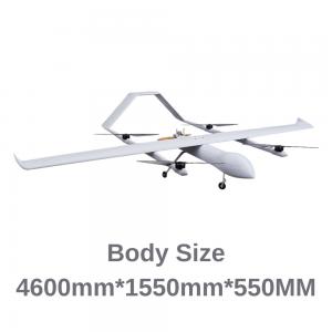
| Parameter Configuration Aerial Mapping Drone HX4HFW460 | |
|---|---|
| Drone Name | HX4HFW460 Aerial Mapping Drone |
| Wings Length | 4.6m |
| Cruise Speed | 23-26s/m |
| Task Load | 3-15kg |
| Drone Length | 1.55m |
| Practical Ceiling | 5000m |
| Wind Resistance | Level 6 |
| Battery Life | 4-6h |
| Motor Wheelbase | 1.5m |
| Route Accuracy | 1. |
| High Precision | 1. |
| Flight Radius | 280km |
| Stall Speed | 40km/h |
| Number of Waypoints | 6400 point |
| Power Type | Gasoline hybrid |
| Image Transmission | SD video transmission 30 kilometers |
| Maximum take-off weight | 30KG |
FAQ for Product & Brand Customization
Q1. Can you customize according to my requested Indusrtrial Inspection Drone parameters?
A: Yes. We have the support of the entire industry chain of industrial drones, so we can not only carry out the R&D, design, and production of industrial drones according to your requirements, but also give you many constructive suggestions based on our past case experience.
Q2. Can I make a sample order for custom drone?
A: Yes, we welcome sample order to test and check out quality.
Different samples in an order are acceptable.
Q3. Is it OK to print my logo on product?
A: Yes.
Q4. What about the lead time?
A:Sample needs 7-10 days.
Q5. Do you have any MOQ limit for drone?
A: We don't have any MOQ, 1piece is acceptable.
Q6. How do you ship the order and how long does it take to arrive?
A: We usually ship by air transportation.
It takes around 7-12 days to arrive in most situations. Sea transportation is also available.
Q7. How to make an order for drone?
Step1: Let us know your requirements.
Step2: We quote according to your requirements or our suggestions.
Step3: Customer confirms the order and places deposit for formal order.
Step4: We arrange the production.