
Add to Cart
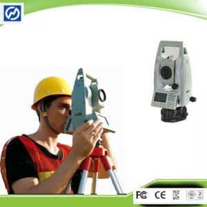
Geodetic Survey Bluetooth and USB Robotic Total Station
Compact and Lightweight Designed, easy to carry and setup. With powerful measurement module, Stable Dual-axis Compensation system, and Intelligent Calibration Software, HTS-360R improves the speed and distance of measurement efficiently. Using STM32 architecture and high-grade dustproof and waterproof structure design, Comprehensively enhance the overall performance of HTS-360R.
The HTS-220/R is configured with advanced dual-axis compensatorfor auto error elimination and auto accuracy compensation.
The absolute encoding disk ensures high accuracy, efficiency and stable performance. Initialization is needless but to measure the angle immediately as the HTS-220/R is turned on. The azimuth information won’t be missed even the HTS-220/R is power-off unexpectedly.
The STM32 MCU based on ARM Cortex™-M processor enables the HTS-220/R has extra high processing speed and low-power consumption.
The Bluetooth wireless technology makes HTS-220/R accessible to any data collector for real-time communication. The third party field software such as Carlson SurvCE is fully compatible with the HTS-220/R.
The display and keyboard with backlight for working in the dark.
Support diagonal eyepiece for observations at steep line of sight.
The proprietary HI-TARGET Calibration software is accessible for real-time diagnosis to ensure trouble-free operation
| Model | HTS-220R |
| Angle Measurement | |
| Measurement Method | Absolute Encoding |
| Minimum Readout | 1″/5″/10″(0.3mgon/1.5mgon/3mgon)adjustable |
| Angle Accuracy | 2″ |
| Distance measurement(HTS-220 with reflector) | |
| Single prism | 3000m |
| Three Prisms | 6000m |
| Reflective Sheet | 800m |
| Accuracy | 2mm+2ppm |
| Measuring time(Fine/Quick/Tracking) | 1.5s / 1s / 0.5s |
| Distance Measurement(HTS-220R reflectorless) | |
| Reflectorless Range | 350m |
| Single Prism | >7500m |
| Accuracy | 3mm+2ppm |
| Measuring time | 1.5s |
| Telescope | |
| Magnification | 30X |
| Field of View | 1°30′ |
| Minimum Focusing Distance | 1.5m |
| Reticle | Illuminated |
| Compensator | |
| System | Single-axis liquid tilt sensor/Dual-axis (optional) |
| Working Range | ±3′ |
| Setting Accuracy | 1″ |
| Communication | |
| Bluetooth | Optional |
| Interface | Standard RS232,SD card,USB pen drive,mini-B |
| Internal Data Memory | Approx. 20,000 points |
| Data Format | ASCII |
| Operation | |
| Operation system | Real-time Operation System |
| Display | High resolution backlight black and white display with contrast adjustment/ |
| Graphics: 280 x 160 pixels | |
| Character: 6 lines x 25 characters | |
| Keyboard | 2 sides Alphanumeric backlit crystal keyboard |
| Laser plummet | |
| Type | Laser point, 4 brightness levels adjustment / Optical plummet (optional) |
| Centering Accuracy | 1 mm at 1.5m instrument height |
| Power supply | |
| Battery Type | Rechargeable Li-ion battery |
| Voltage/Capacity | ZBA-400: 7.4V (DC) / 3000mAh |
| Operating time with ZBA-400 | Optimal 16 hours5 / 10 hours(typical) |
| Measuring times | Approx 12000 times |
| Weight | |
| Weight (Incl.Battery & Tribrach) | Approx 5.5kg |
| Environmental | |
| Operating temperature | below 20°C to above 50°C |
| Storage temperature | below 40°C to above 70°C |
| Dust &Water Proof (IEC60529 Standard)/Humidity | IP65, 95%, non-condensing |

