Add to Cart
Precision, velocity, and balance are fundamental aspects for the optimal performance of any mobile entity. In the realm of intricate vehicles such as airplanes, autonomous vehicles, ships, spacecraft, submarines, and even unmanned aerial vehicles (UAVs), the demand for a precise system to uphold and regulate flawless motion is imperative. Inertial navigation systems play a crucial role in enabling these vehicles to execute their tasks securely and accurately, eliminating the reliance on GPS.
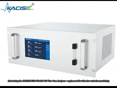
The KsINS-01 integrated communication and guidance cooperative navigation system is designed for UAV swarm formation flight, integrating satellite navigation and data links to deliver accurate spatio-temporal benchmarks for UAVs. With Beidou third-generation B1 and B3 frequency signal reception, the system facilitates inter-node networking communication and boasts high-precision space-time synchronization functions. Its spatio-temporal synchronization accuracy exceeds 0.1m/1ns under satellite effective conditions and is superior to 5m/5ns under satellite rejection conditions.
● High-precision spatio-temporal synchronization between nodes based on carrier difference
● High-precision spatio-temporal synchronization between nodes under satellite rejection conditions
● In-depth integrated design of satellite navigation and data link
● Highly reliable networking and data transmission between nodes
Performance indicators :
| Satellite positioning accuracy (2σ) | Level: 6m, elevation: 8m |
| Data link working frequency band | 3.4GHz~3.6GHz |
| Frequency hopping rate | 80000 hops/s |
| Communication distance | 100km |
| Communication rate | 200kbps |
| Number of supported nodes | 64 |
Spatiotemporal synchronization accuracy when satellites are available (RMS) | 0.1m/1ns |
Spatiotemporal synchronization accuracy in case of satellite rejection (RMS) | 5m/5ns |
Application environment :
| Working/storage temperature(℃) | -55℃ ~+70℃ |
| Dynamic Range | Speed: -2000m/s ~ 2000m/s; Acceleration: -30g ~ 30g; acceleration: -5g/s ~ 5g/s. |
| Mechanical properties | Endurance shock environment: half sine wave 20g, 11ms Endurance vibration environment: typical drone vibration environment |
Physical properties:
| Dimensions | 160mm x 150mm x 56mm |
| Installation dimensions | 160mm x 150mm |
| weight | Host ≤ 12.5kg |
External Interface:
| Power Requirement | 18V~36V DC, power consumption ≤ 30W, allowed power interruption is no more than 5ms |
| Input/output interface | 2 RS-422, 1 RS-232, 1 100M Ethernet |
| Data output frequency | 10Hz (typical) |