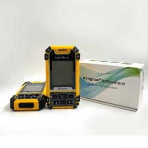
Portable Yellow&Black Color Area Measuring Equipment LCD Screen Display GPS GNSS Land Survey Equipment Wanggan S1 GPS land survey equipment Wangga...
Add to Cart
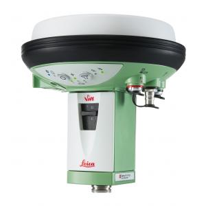
Land Survey Software Leica GS15 GNSS receiver RTK CCP code increased positions in challenging environments product name GS15 GNSS receiver RTK CCP cod...
Add to Cart

High Precision GPS RTK Module Land Survey GPS Module GNSS Module Product descriptions from the supplier Overview Application: ● Location of base stati...
Add to Cart
Data Acquisition System 20W 1.92km2 Triple Echo Livox Avia Laser Sensor UAV LiDAR System Land Surveying UAV LiDAR Scanning System with Triple Echo Liv...
Add to Cart
Land Surveying Grip and Slide Control Prism Pole Tripods Silver Color Heavy Duty Tripods 1.2m-1.8m Model: PTS Specifications: Model PTS Color Silver M...
Add to Cart
Land Surveying Gps Gnss Receiver Land Surveying Gps The V60 is a more compact-design and higher-performance GNSS RTK system, besides its rugged design...
Add to Cart
Wintape 30-Meter (100ft) Long Distance Fiberglass Surveyor Tape Measure Dual-Sided Land Surveying Measuring Tape Product Description The 30-meter (100...
Add to Cart
CHC Brand Huayi GPS E91 GNSS Receiver with 624 Channels for Land Survey GPS Specification: model CHC E91 Gnss Channel 624 Satellite Tracked GPS L1CA/L...
Add to Cart
All-Metal Single Tilt Prism- Ideal as Land Surveying Equipment, Orange Features * Leica system. * Effective diameter: 64mm,coated with copper. * Prism...
Add to Cart
High precision 5mm@30m 1000000points/s high frequency LiDAR mobile mapping system HiScan-R with 420m range HiScan-R is a Riegl LiDAR based, lightweigh...
Add to Cart
NLOS Long distance Land Survey monitor video link for vehicles/armoured vehicle Introduction ST9520CZH Digital NLOS transmitter is of high power, high...
Add to Cart
Main Applications: 1. Construction Layout 2. Electric power transportation 3. CORS application 4. CORS site 5. Control survey 6. Data collection 7. Wa...
Add to Cart
Product Description: 3D Mapping Drones are high-resolution-surveying unmanned aerial vehicles (UAVs) for mapping and surveying purposes. It is designe...
Add to Cart
SOUTH Total Station Surveying Equipment Best Price Automatic Total Station SOUTH Total Station NTS-332R10 Instrument Model NTS-332R10 Distance Measure...
Add to Cart
Land Surveying Equipment, GPS/Gnss Receivers, Mapping Lithium Ion Battery Lithium Battery 11.1V 6600mAh Pack We can make any customized battery for or...
Add to Cart
Camera Drone Five-eye Tilt Photogrammetry Camera 24 Megapixel Tilt Five Camera for Land Survey Mapping Description Equipped with five high-pixel multi...
Add to Cart
HXN1-R 16m/S Cruising Speed Land Surveying 1.4Hours Endurance UAV Camera 3D Mining Urban Modeling Aerial Mapping Drone ⇨Foldable Body The flexible and...
Add to Cart
Multiple Area Measure Mode Digital 1000meter Laser Rangefinder for Land Survey FEATURES ● Min/max measurement ● Continuous measurement ● Stake-out fun...
Add to Cart
Lemo FNG.0B.307.CLAD52Z with lanyard for survey instruments GNSS Features: Lemo FNG 7pin male plug with lanyard 0B size, also 1B 2B 3B avalaible Appli...
Add to Cart
Waterproof IP67 High Gain GPS Antenna , External GNSS Surveying Antenna TOP-GPS13 (TOP-SUR01) Precision L1 L2 gnss external gps survey antenna magneti...
Add to Cart