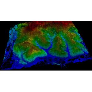
GS-260X LiDAR Scanning System HESAI XTM2X Sensor High Accuracy Terrain Mapping UAV Surveying Geosun gAirHawk Series GS-260X LiDAR Scanning System gAir...
Add to Cart
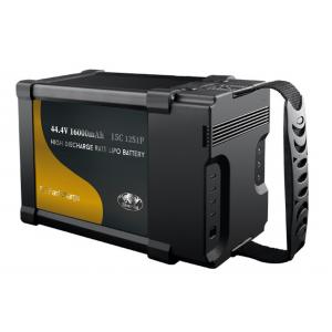
High Power 44.4V 16000mAh Lithium Ion Battery For Plant Protection UAV, Surveying Mapping Drones Rated Capacity 16000 mAh @ 0.2C Min. Capacity 15500 m...
Add to Cart

UAV Mapping Drone Long range aerial survey fixed wing uav mapping drone Long range aerial survey fixed wing uav mapping drone Material Carbon Fiber Fu...
Add to Cart
Product Description: 3D Mapping Drones are remotely-operated-UAV-mapping machines designed for autonomous-drone-surveying operations. With a 600mm whe...
Add to Cart
30KM Very Larger Range UAV Video Data Link Mavlink 1080P for Mapping Drone 30km Fixed Wing UAV Data Link Support Pixhawk High Definition Multimedia In...
Add to Cart
High precision GPS UAV RTK module Land survey GPS module *, *::before, *::after {box-sizing: border-box;}* {margin: 0;}html, body {height: 100%;}body ...
Add to Cart
MYUAV Cable power system used for UAV and 4 rotors drone Law enforcement Application Law enforcement, monitoring, reconnaissance, survey 1. Typical ch...
Add to Cart
UAV Electro Optical Tracking System Real Time Imaging And Reconnaissance Proposal Application Public security emergency investigation, fire rescue, mi...
Add to Cart
FS60- UAV hyperspectral measurement system The FS60 unmanned Superspectral Survey system used a high signal-to-noise ratio and a high-speed CCD imagin...
Add to Cart
Dji Phantom 4 Rtk Drone Every inch of it Spirit Phantom 4 RTK is a small multi-rotor high-precision aerial survey uav, aiming at low-altitude photogra...
Add to Cart
Product Description: VTOL Drones are an incredibly versatile, easy to use and reliable product. They offer a unique combination of features, including...
Add to Cart
FZ-120 Tethered Drone Description of FZ-120 Tethered Drone FZ-120 is a very unique hexacopter featuring high pressure molding full carbon fiber body, ...
Add to Cart
UAV LiDAR Scanning System Geosun GS-100C+ Livox Avia Topographic Surveying And Mapping Solution 5-Power supply Power supply for galvo head and control...
Add to Cart
The D04 is a data transmission device wirelessly connected to the computer, which is particularly suitable for surveying and mapping. It can transmit ...
Add to Cart
Luxury 2020 TP-Link Powerline GPS Survey Antenna Long Range Video Wireless Hidden Cameras Spy Transmitter for Fire Fighting ultra-low latency H.264 CO...
Add to Cart
HX4HFW460 VTOL 3D 4D Urban Modeling Surveying Aerial Mapping Drone Fully Automatic Driving Fixed Wing UAV Camera Oil-powered fixed-wing UAV Features D...
Add to Cart
Light and excellent fatigue strength carbon fiber propellers for Aerial Survey UAV Product features: Light, high strength, excellent fatigue strength,...
Add to Cart
Altitude Industrial Drone Used for Police Security, Traffic Monitoring, Site Survey, Eergency Treatment Features 1. This is a high-end for police secu...
Add to Cart
Fullymax 14.8V 22000mAh 4cell Commercial Aerial photography drone industrial drone lipo Battery Pack The 22000mAh UAV battery is typically used in unm...
Add to Cart
Helicopter Survey Gimbal Accessories Stabilizer RC Car UAV Camera Vibration Shock Control GR2 Series Cinema Vibration Is Product Description Choose GR...
Add to Cart