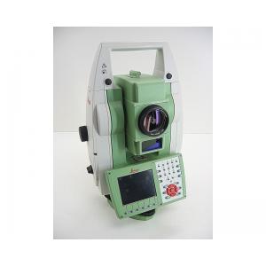
Land Survey Software TS15 total station PUK code tunnel section software product name TS15 total station PUK cod brand Leica model TS15...
Add to Cart
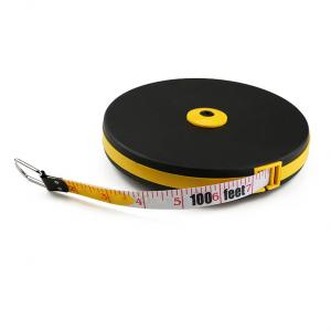
Wintape 30-Meter (100ft) Long Distance Fiberglass Surveyor Tape Measure Dual-Sided Land Surveying Measuring Tape Product Description The 30-meter (100...
Add to Cart

All-Metal Single Tilt Prism- Ideal as Land Surveying Equipment, Orange Features * Leica system. * Effective diameter: 64mm,coated with copper. * Prism...
Add to Cart
High Precision GPS RTK Module Land Survey GPS Module GNSS Module Product descriptions from the supplier Overview Application: ● Location of base stati...
Add to Cart
2.5kg 330m@80% range 15mm @150m range accuracy ARS-200 High Precision Airborne LiDAR Survey with 5 times echoes ARS-200 high precision airborne LiDAR ...
Add to Cart
NLOS Long distance Land Survey monitor video link for vehicles/armoured vehicle Introduction ST9520CZH Digital NLOS transmitter is of high power, high...
Add to Cart
Data Acquisition System 20W 1.92km2 Triple Echo Livox Avia Laser Sensor UAV LiDAR System Land Surveying UAV LiDAR Scanning System with Triple Echo Liv...
Add to Cart
Land Surveying Grip and Slide Control Prism Pole Tripods Silver Color Heavy Duty Tripods 1.2m-1.8m Model: PTS Specifications: Model PTS Color Silver M...
Add to Cart
Product Description: 3D Mapping Drones are high-resolution-surveying unmanned aerial vehicles (UAVs) for mapping and surveying purposes. It is designe...
Add to Cart
SOUTH Total Station Surveying Equipment Best Price Automatic Total Station SOUTH Total Station NTS-332R10 Instrument Model NTS-332R10 Distance Measure...
Add to Cart
CHC Brand Huayi GPS E91 GNSS Receiver with 624 Channels for Land Survey GPS Specification: model CHC E91 Gnss Channel 624 Satellite Tracked GPS L1CA/L...
Add to Cart
Land Surveying Gps Gnss Receiver Land Surveying Gps The V60 is a more compact-design and higher-performance GNSS RTK system, besides its rugged design...
Add to Cart
Rugged and reliable: 1. IP67, withstands a 3-meter natural fall onto concrete 2. Rapid tracking and optimum avoidance or reduction of obstruction and ...
Add to Cart
Multi-function Land Survey Equipment GPS for Land Survey Digital Survey Machine Main Features and Benefits: It measures the length, width and area of ...
Add to Cart
Camera Drone Five-eye Tilt Photogrammetry Camera 24 Megapixel Tilt Five Camera for Land Survey Mapping Description Equipped with five high-pixel multi...
Add to Cart
HXN1-R 16m/S Cruising Speed Land Surveying 1.4Hours Endurance UAV Camera 3D Mining Urban Modeling Aerial Mapping Drone ⇨Foldable Body The flexible and...
Add to Cart
Multiple Area Measure Mode Digital 1000meter Laser Rangefinder for Land Survey FEATURES ● Min/max measurement ● Continuous measurement ● Stake-out fun...
Add to Cart
Land Surveying Equipment, GPS/Gnss Receivers, Mapping Lithium Ion Battery Lithium Battery 11.1V 6600mAh Pack We can make any customized battery for or...
Add to Cart
Affordable Proton Magnetometer Magnetic Survey Instruments Proton magnetometer magnetic survey Instruments aometimes called the “grandfather” of magne...
Add to Cart
Reusable 2.5m Inflatable Earth Ball Fire Retardant UV Protected Printing Durable Attractive Earth Balloons Globe UV Protected Printing for Science Res...
Add to Cart