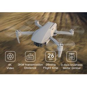
Product Description: 3D Mapping Drones are high-resolution-surveying unmanned aerial vehicles (UAVs) for mapping and surveying purposes. It is designe...
Add to Cart
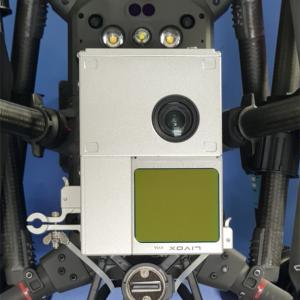
Geosun Drone LiDAR GS-100C+ Support DJI Matrice 300 Yuneec H850 Aerial Mapping Geosun gAirHawk Series GS-100C+ Drone LiDAR Drone LiDAR scanning system...
Add to Cart
Experience High-Performance With Our Aerial Mapping Drone VTOL Drone, 90-Minute Flight Time 2KG Payload Capacity Wingspan 1700 mm Length 1250 mm RTF W...
Add to Cart

UAV Mapping Drone Long range aerial survey fixed wing uav mapping drone Long range aerial survey fixed wing uav mapping drone Material Carbon Fiber Fu...
Add to Cart
920m@60% range 15mm@150m range accuracy 4.5kg ARS-1000 Lightweight UAV Mapping System with 10~200 scans/s scan speed ARS-1000 Lightweight UAV Mapping ...
Add to Cart
Product Key Features of Drone Video Transmitter: Model:CD15NMT-mini Range:15km Weight:Tx 110g Rx 110g Dimension:88x55x17mm Video&Data:IP Ethernet ...
Add to Cart
Aerial Internal Flexible PCB FPC 4G Mobile Adhesive Patch Antenna 2dbi With 1.13 RF Cable Electrical Characteristics Electrical Specification Frequenc...
Add to Cart
Unmaned Aerial Vehicles professional for aerial Inspection Drones Hexacopter Features: Weight:5.8kg including batteries; Payload:5kg Vertical Accuracy...
Add to Cart
Our ACE-WRJ401 professional unmanned aerial vehicle camera drones is developed from our 2.4G 4Axis GYRO 7CH RC Quadcopter WRJ400 by adding Gimbal, Tel...
Add to Cart
COFDM Video Data Hdmi Wireless Sender & Receivers for Mapping Drones/UAV/helicopter Product description: The Wireless HD Video transmitter system ...
Add to Cart
2.4G 5.8G UAV Aerial Photography Map Transmission Drone Receiver Antenna 5G 5.8G UAV aerial photography map transmission mapping model aerial data tra...
Add to Cart
Surveying & Mapping Drone CT-15 Rotor 6 Stage Fixed Wing Drone Introduction: CT-15 fixed-wing unmanned aerial vehicle is a composite wing aircraft...
Add to Cart
Electric Powered 2 Hours Fixed Wing Drone Aerial Surveillance Surveying Mapping UAV Product features: Light, high strength, excellent fatigue strength...
Add to Cart
Product Description: Tethered Drone Station Product Overview The Tethered Drone Station is an innovative and versatile product designed for aerial map...
Add to Cart
IP67 Azimuth Magnetic Heading Compass Sensor For Antenna/UAV/Mining Application ●Satellite Antenna Searching ● Navigation Navigation Mapping ● GPS Int...
Add to Cart
UAV Electro Optical Tracking System Real Time Imaging And Reconnaissance Proposal Application Public security emergency investigation, fire rescue, mi...
Add to Cart
Portable Backpack low altitude flight drone Suppression system Model No.:VBE-K1.0 Product Description: In recent years, It is rapid development that c...
Add to Cart
ZD-GR5000A Vehicle omnidirectional UAV jamming system 1. Description Nowadays, the small drones with slow speed and low flying height become popular i...
Add to Cart
Target Positioning Electro Optic System For Unmanned Aerial Vehicle TS01GD support mapping, surveilliance,and target auto-tracking.etc functions,also ...
Add to Cart
FW-M25-KV100 Brushless Motor for Drone Electric Brushless DC MotorFW-M25-KV100 Brushless Motor for Drone Description of Electric Brushless DC Motor fo...
Add to Cart